Code
library(sf)
library(tmap)
library(dplyr)
library(geosphere)
library(ggplot2)
library(stringr)
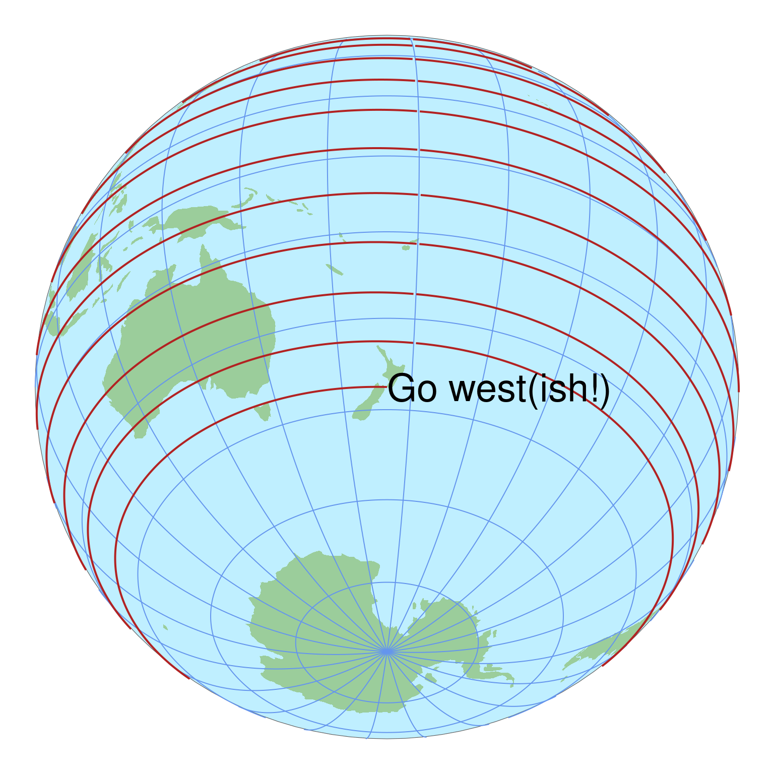
source("~/Documents/code/30-day-maps-2023/maps/utils.R")A map that helps you to navigate.
While not really filling the brief, these maps confirmed for me that there are still quite a few issues dealing with global map projections in the R spatial ecosystem.
I hand made the graticule in these maps using code from a sourced R file which trims the graticule to only extend across the visible extent, because neither tmap nor ggplot2 successfully applied their ‘native’ graticule in this orthographic projection without errors.
geosphere is yet another excellent package from the excellent Robert Hijmans at UC Davis, and its destPointRhumb function is helpful here in building the rhumb line corkscrewing around the globe.
library(sf)
library(tmap)
library(dplyr)
library(geosphere)
library(ggplot2)
library(stringr)
source("~/Documents/code/30-day-maps-2023/maps/utils.R")start_lat <- -41.3
start_lon <- 174.75
start <- c(start_lon, start_lat)
ortho_proj <- get_ortho_proj(start)
aeqd_proj <- get_azimuthal_eq_dist(start)
bearing <- -88.5
end_lat <- 45
step_length <- 5e4
last_pt <- start
lox <- list()
transect <- last_pt
i <- 1
while (last_pt[2] < end_lat) {
next_pt <- geosphere::destPointRhumb(last_pt, bearing, step_length)
if (next_pt[1] > last_pt[1]) {
lox[[i]] <- transect
i <- i + 1
transect <- c(next_pt)
} else {
transect <- c(transect, next_pt)
}
last_pt <- next_pt
}
lox[[i]] <- transect
hemisphere <- get_hemisphere(start, crs = aeqd_proj)
lox_sf <- lox %>%
lapply(unlist) %>%
lapply(matrix, ncol = 2, byrow = TRUE) %>%
st_multilinestring() %>%
st_sfc() %>%
st_sf(crs = 4326) %>%
st_cast("LINESTRING") %>%
st_transform(aeqd_proj) %>%
st_intersection(get_hemisphere(start, aeqd_proj)) %>%
st_transform(ortho_proj)
# st_cast("POINT")
data(World)
world <- World %>%
st_cast("POLYGON") %>%
st_transform(ortho_proj) %>%
dplyr::filter(!(st_is_empty(geometry)))
graticule <- get_graticule(centre = start) %>%
st_transform(ortho_proj)
globe <- st_point(c(0, 0)) %>%
st_buffer(6378137) %>%
st_sfc(crs = ortho_proj) %>%
st_sf()tmapinstruction <- st_point(c(0, 0)) %>%
st_sfc(crs = ortho_proj) %>%
st_sf() %>%
mutate(label = "Go west(ish!)")
tm_shape(globe) +
tm_fill(fill = "lightblue1") +
tm_shape(world) +
tm_fill(fill = "darkseagreen3", lwd = 0) +
tm_shape(graticule, is.main = TRUE) +
tm_lines(col = "cornflowerblue", lwd = 1) +
tm_shape(lox_sf) +
tm_lines(col = "firebrick", lwd = 2) +
tm_title("Go west(ish!)", position = c(0.5, 0.5), size = 2) +
tm_layout(frame = FALSE)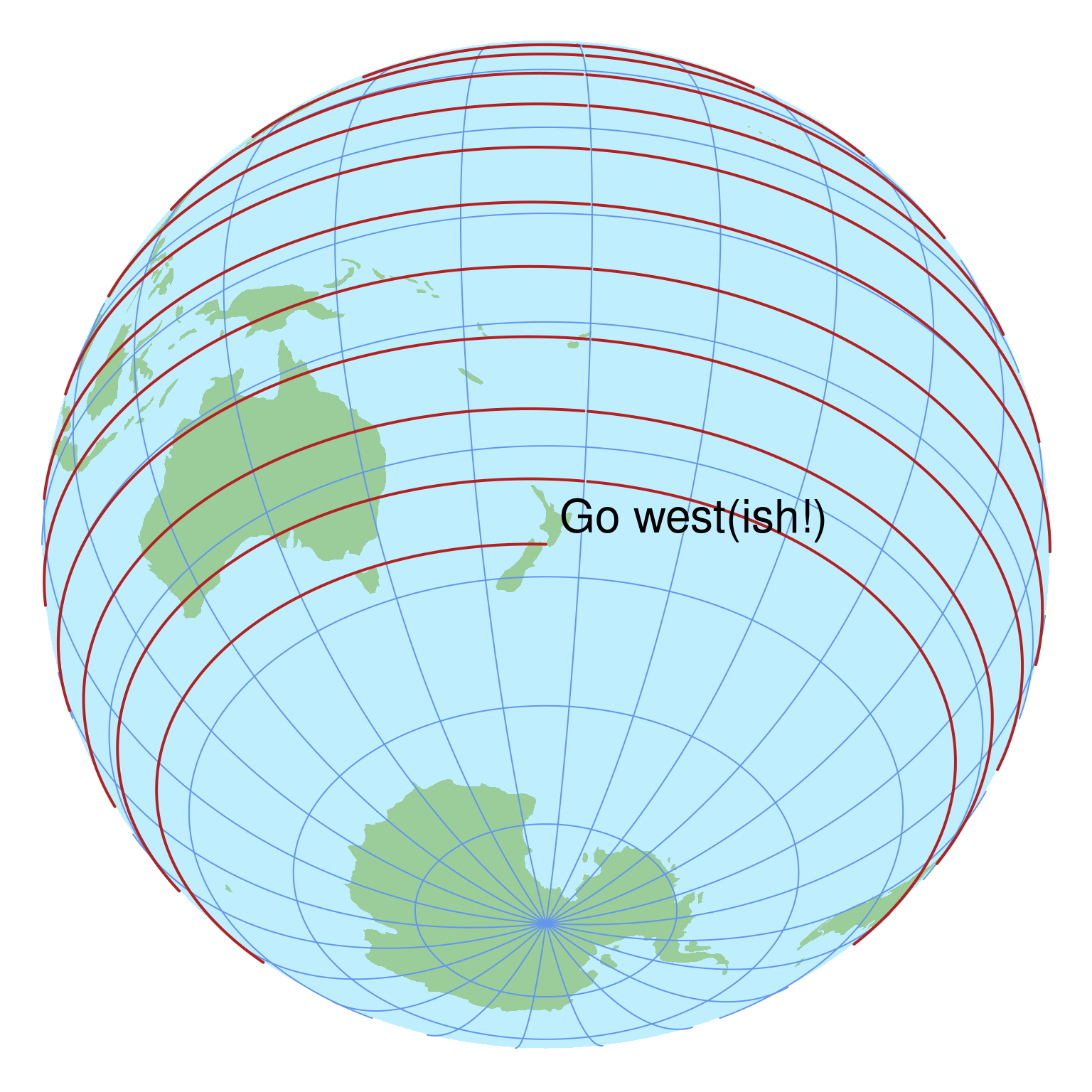
ggplot2ggplot(globe) +
geom_sf(fill = "lightblue1") +
geom_sf(data = world, fill = "darkseagreen3", linewidth = 0) +
geom_sf(data = graticule, colour = "cornflowerblue",
linewidth = 1 * 25.4 / 72.27) +
geom_sf(data = lox_sf, colour = "firebrick",
linewidth = 2 * 25.4 / 72.27) +
annotate("text", x = 0, y = 0, label = "Go west(ish!)",
hjust = 0, size = 10) +
theme_void()